


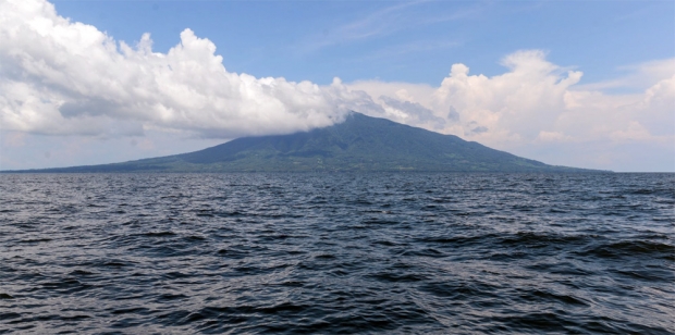
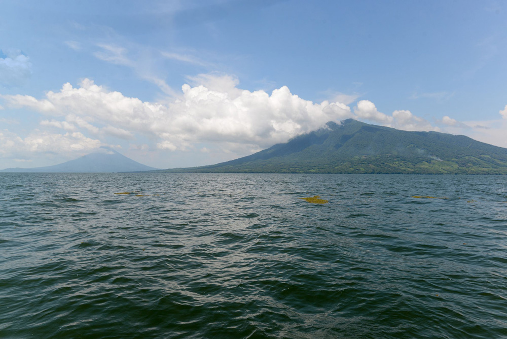
Southwest of the Maderas volcano, where the Rivas coast is a line fading into the distance, Lake Cocibolca’s inmensity is on prominent display: breezes softly comb stretches of water that are seemingly endless. Sonar has marked this as the deepest point on the route for the “Great Inter-Oceanic Canal” through a lake that the Spanish conquistadores, stunned upon encountering it, named, “the Sweet Sea.”
Economist Juan Sebastián Chamorro, captain of the ship Calypso, backed up by a Humminbird 980sci side-scan sonar, calculated that on the muddy shores of El Tule, in the municipality of the San Juan River, there are a scant 10 to 15 kilometers (six to nine miles) along the canal route traced by the Hong Kong Nicaragua Canal Development Investment Co., Limited (HKND) that are deep enough to accomodate the huge new Post-Panamax megaships (the latest in super-sized cargo ships). (It is these ships that are the rationale to build this new canal.)
“They’d have to dredge almost the whole route, because what we have is that only a single stretch of the 105 km [65 miles] planned has a depth between 27 and 30 meters [88 and 99 feet],” said Chamorro while he maneuvered the Calypso to keep it from running aground. After analyzing the results, he realized the depths included in the map of the proposed route of the canal were identical to those on maps of the lake made in 1899 and 1972 (and thus unlikely to have been the results of more recent measurements).
Lake Cocibolca has always been in the sights of canal-making ventures. Since the 19th Century, first with the U.S. government and now with the Chinese businessman Wang Jing, who holds the franchise granted by Daniel Ortega’s administration, dozens of projects have been cooked up premised on taking advantage of the lake to sail great ships. But few have made scientific studies of the lake’s depth and the implications of the dredging that would be needed to realize the planned canal.
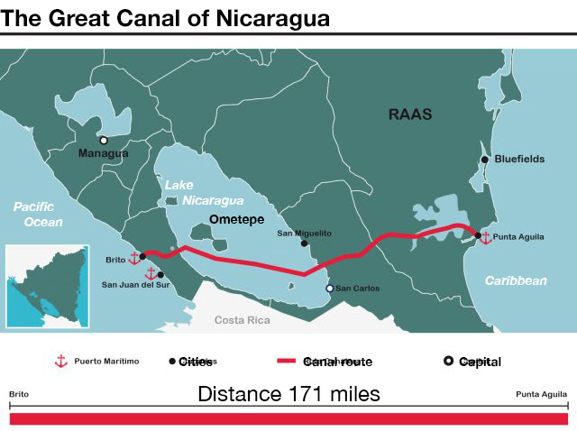
Last July, HKND’s chief engineer, Dong Yunsong, announced the route for the “Grand Canal,” a route which was not all that different from the one in studies sketched out under former-President Enrique Bolaños. “The Canal will have a total length of 278 kilometers [173 miles], of which 105 are through Lake Cocibolca,” Dong said through a translator.
In Managua, Dong said that the Canal would measure 230 to 250 meters (755 to 820 feet) wide, and that its depth would range between 27.6 and 30 meters (91 and 99 feet). Immediately, Nicaragua’s scientific community intensified its alarm over the future of the Great Lake, Latin America’s second largest. The reason: its scant depth.
The last bathymetric or topographic registry made of Cocibolca dates back to 1972. Though outdated, it is the latest reference available. That report gave the first indications of the unavoidable dredging that the lake would have to undergo to meet the projected specifications of the canal. How much would need to be excavated from the lake’s bottom to run the pit through the waterway? What repercussions would that have on flora and fauna? Would it affect the quality of the water? These are among the questions officials have yet to answer.
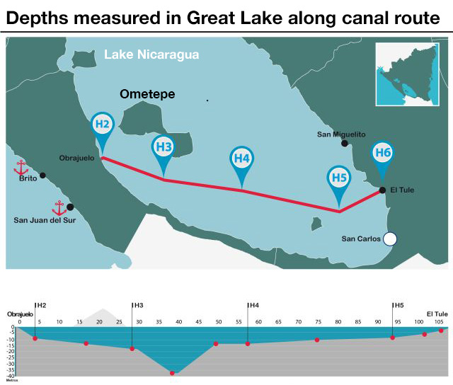
To facilitate the measurement of the depths of the Cocibolca, the 105 kilometer route was divided up into several sections marked off, following the map submitted by HKND. The first section went from Obrajuelo to H2, the second section from H2 to H3, the third from H3 to H4, the fourth from H4 to H5, and the fifth from H5 to Tule.
On September 27, an expedition for Confidencial, led by sailors Juan Sebastián Chamorro, commanding the Calypso, and Pedro Joaquín Chamorro (President of the tourism commission of the National Assembly) piloting the boat La Bachi, set sail from the coastal town of Obrajuelo, near the Las Lajas river in Rivas. [Pedro Joaqin is the brother of Confidencial’s editor, Carlos Chamorro, and Juan Sebastian is his cousin.] The Canal pit would exit the lake and cut through to the Pacific right through this small town.
Environment
12.05.14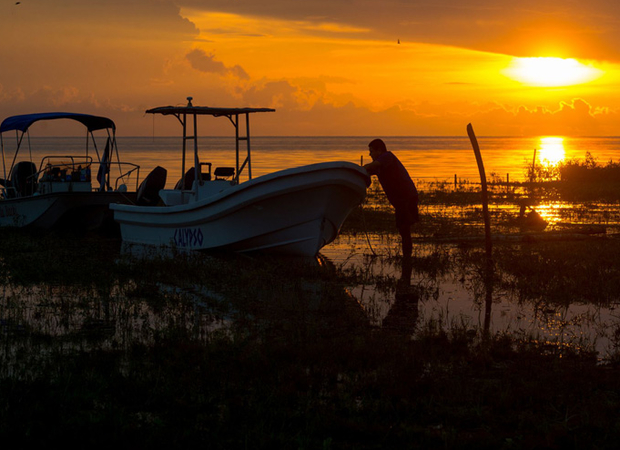
A Catastrophe for Nicaragua’s Great Lake
from ConfidencialThe day’s mission was to cover the 105 kilometers (65 miles) of the Canal route that were within the lake, following the line drawn by HKND as faithfully as possible. To get coordinates, the sailors traced the map given to them by Dong Yunsong.
This trip was divided by five marks to facilitate measuring the lake bottom in sections. “The five points chosen overlapped with the route supposedly laid out for the canal with a real route done with a GPS. First we traced the points and then we entered them into the GPS, and then followed it to take some depth samples,” said Pedro Joaquín Chamorro, laying out the technical points.
Eleven degrees 24 minutes 385 seconds North were the coordinates. The waters were choppy. The heading was toward the second mark, or H2 as they abbreviated it, five kilometers (three miles) northwest of Obrajuelo, where the Canal route makes a small break toward the island of Ometepe and then proceeds in a straight line.
The first stretch we travel—from Obrajuelo to H2—is five kilometers (three miles) point to point. The depth marked is 2.1 meters (6.8 feet), 27 fewer than the Canal requires. The sonar picked up rocky formations that begin on the coast and go 900 meters (just over half a mile) in. On the sonar screen the rocks appear as corrugated irregularities on the lake bottom. As we moved away from shore, the 2.1 meters (6.8 feet) of depth increased to 8.7 meters (28.5 feet). We have reached H2.
The next stretch is from H2 to H3. The peak of the Concepción volcano, in Ometepe, looks greener as we approach. The current sweeps along some trash. The sonar determines an average depth of 12.3 meters (40 feet) between H2 and H3 and at one point reaches 18 meters (60 feet). La Bachi’s motors speed up and on Calypso’s radio we could hear the voice of Representative Pedro Joaquín Chamorro:
“La Bachi to Calypso, over,” said Chamorro.
“Go ahead, Pedro,” replied Juan Sebastián.
“We’re almost on top of the trench!” came the reply.
0
0
1
7
46
ChinaFile
1
1
52
14.0
Normal
0
false
false
false
EN-US
JA
X-NONE
/* Style Definitions */
table.MsoNormalTable
{mso-style-name:"Table Normal";
mso-tstyle-rowband-size:0;
mso-tstyle-colband-size:0;
mso-style-noshow:yes;
mso-style-priority:99;
mso-style-parent:"";
mso-padding-alt:0in 5.4pt 0in 5.4pt;
mso-para-margin:0in;
mso-para-margin-bottom:.0001pt;
mso-pagination:widow-orphan;
font-size:12.0pt;
font-family:Cambria;
mso-ascii-font-family:Cambria;
mso-ascii-theme-font:minor-latin;
mso-hansi-font-family:Cambria;
mso-hansi-theme-font:minor-latin;}
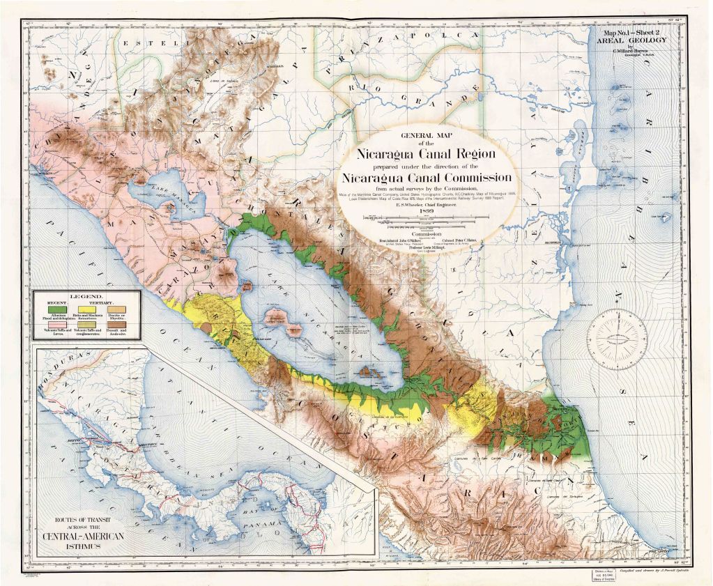
Map made by the U.S. Army Corps of Engineers in 1899.
When the U.S. was interested in cutting an interoceanic path through Nicaragua, it commissioned studies of the terrain which were presented to the authorities to determine the project’s viability.
One of those documents was a hydrographic study done in 1899, carried out by Rear Admiral John G. Walker, Chief of the U.S. Bureau of Navigation; Colonel Peter C. Hains, of the U.S. Army Corps of Engineers; and Professor Lewis M. Haupt, a civil engineer.
The measurements of Cocibolca made by the Americans determined that there is a space from the Maderas volcano running West to East where depths vary between “80 to more than 100 feet,” (between 24 and 36 meters).
In 1972, the National Development Institute of Nicaragua (INFONAC) commissioned a bathymetric study of the Great Lake, which established that the lake’s deepest zones matched those the U.S. researchers found, from Maderas towards the Solentiname islands. That is the last study available currently, when the Canal venture is now once again seducing Nicaragua with a promise of progress. But 42 years later, has the depth of the lake remained the same, taking into account the millions of pounds of sediment that have accumulated in the enormous body of water?
* * *
“It’s the San Ramón trench!!” cried Pedro Joaquín Chamorro from La Bachi.
The sonar on the Calypso had doubled the depth measures. There’s 29 kilometers (18 miles) between H3 and H4. Of those, about 10 to 15 kilometers (6 to 9 miles) have depths between 18 and 36 meters (59 and 118 feet). Just enough for the monstrous ships to which the “Great Canal” aims to offer its services.
At the end of the expedition, Pedro Joaquín Chamorro, said that only along 10% of the Canal route in Lake Cocibolca would it not be necessary to dredge to open up the submerged pit. “It’s what’s called the San Ramón trench, which goes towards Zanata [island]. The route cuts across it, not parallel to it.”
Zanata is a small island, six kilometers (four miles) north of H4, where we continued to take sonar measurements. From that point, the coast of Rivas appears as a thin line on the horizon. The small waves in this area allowed us to look upon the Maderas volcano, which was once clad in greenery and now was bare thanks to the parcels cleared through slash and burn agriculture.
To calculate the width of the trench, the second day of the expedition we navigated to the southernmost point of Ometepe island, going South toward the Orosí volcano. We measured similar depths in the three kilometers (2 miles) we covered.
Juan Sebastián Chamorro said that to get more exact measurements of the trench we would need to cover more of the lake and to look at it in its entirety. “We would have to thoroughly probe about 125 square kilometers [48 square miles], which is beyond the scope of our exploration,” he said.
At this point, the depth of the lake started decreasing as we moved toward H4. The sonar once again measured 12 meters (39 feet) as the average depth. Meaning that in the 29 kilometers (18 miles) between H3 and H4, only 10 or 15km (six or nine miles) reach the depths required by Post-Panamax megaships.
“Over, over. Pedro, we can move on to the next section,” announced Juan Sebastián.
“Copy, Juan,” La Bachi’s captain answered. The motors roared and Ometepe remained behind as we headed toward Cocibolca’s Chontaleña coast.
In addition to the sonar measurements, the Confidencial expedition took several samples from the Cocibolca lake bed. Juan Sebastián Chamorro found the same thing in every plunge: a soft bottom made of mud and sand. However, that exploration did not go into the lake floor. “I can’t determine if there are rocks under the mud or how wide the existing mud bed is,” he said.
Establishing all these facts is vital to understanding the magnitude of the dredging HKND would have to take on. It is the first thing that César Avilés Haslam suggested. The veteran engineer had been in charge of projects to dredge Bluefields and Sandy Bay on the Caribbean coast, and Granada and San Jorge on the Great Lake.
“Are we dredging dirt, rock, schist? That determines what kind of equipment you need to use. If you can dredge with suction you take it up and spit it out, or you use a cutter suction dredger. If you have rocks you have to drill and use explosives and take them out with a crane. First you need to know what there is. It’s a rough approximation, but it’s something,” said Avilés Haslam.
Wang Jing’s Canal
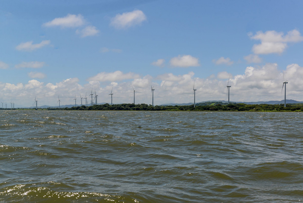
Nicaragua turned over the franchise for the construction and management of the so-called Great Canal to HKND, with Wang Jing as president, director, and sole partner. The route proposed by the Chinese company starts in the western city of Brito on Nicaragua’s Pacific Coast, crosses the Great Lake, and terminates in the Caribbean. The U.S.$50 million proposed canal would be 171 miles long, 65 of which would be within Lake Cocibolca, 820 feet wide, 85 to 100 feet deep, and utilize 12 locks, as well as ports, airports, industrial and tourism complexes, roads, and free trade zones.
Following the projections of canal measurements and the results our measurements turned up, engineer Jaime Matus, President of Nicaragua’s Association of Engineers and Architects (ANIA), calculated how much sediment would need to to be removed from the Cocibolca.
“The calculations add up to 585,720,000 thousand cubic meters (20.69 billion cubic feet) of material,” said Matus. “It’s quite a considerable amount, big!” Matus said he knew nothing about the Canal project, because the association he presides over had not been consulted on the plans, except for being asked to propose how the extracted sediments should be used. But a different mathematical calculation by Matus gave us a more graphic image of how much material would need to be excavated.
“If you piled it up to an average depth of three meters [ten feet], it would take up an area of 19,524 hectares [75 square miles]. It would be the equivalent of spreading this material over half the municipality of Managua, or the municipalities of Catarina, La Concepción, Masatepe, and Tisma,” Matus said.
Another engineer, Donald Delgadillo, a Nicaraguan who lives in the U.S., said he was sure of only one thing. “The volume you have to excavate will be astronomical. And the question is: what would you do with the material that you have dug up? Spread it along parts of the lake bed around the canal route? Reduce the lake depth in areas away from the canal? Move it out onto land?”
HKND engineers said that they would use the material to make a ridge to protect the pit in the Cocibolca, but Avilés Haslam assured us that while he believes that, while building the “Great Canal” is viable, it would not work through the lake.
Several certificates recognizing career accomplishments hang in Avilés Haslam’s living room. He calculated again the matter that needed to be excavated, based on the Confidencial survey.
“You have to dredge 310.4 million cubic meters [10,962 cubic feet] of rock and 65 million cubic meters [2,295 cubic feet] of lime, assuming that the median depth of the lake is 14 and a half meters [48 feet]. And the other depth is 15 meters [50 feet], of which two and a half meters [eight feet] is lime, and 12 meters [39 feet] is rock. And those are estimates based on very limited surveys,” said Avilés Haslam. “They dug way more in Panama and no one screamed bloody murder,” he added.
The web page for the Panama Canal Authority (ACP) states that to extend that interoceanic pass they have removed 41 million cubic meters (1.448 billion cubic feet) along the entire route. Two, three million [71 to 105 million] on the Atlantic side, 30 million [1.05 billion cubic feet] in Gatún Lake and in Corte Culebra, and 8.7 million [307 million cubic feet] on the Pacific side.
Doctor Pedro José J. Álvarez, head of the Department of Civil and Environmental Engineering at Rice University in Houston, thinks that dredging the Cocibolca “would be a megaproject on its own.”
The Nicaraguan scientist, a winner of the U.S. National Water Research Institute’s Clarke Prize, highlighted concerns over the damages to the Cocibolca that dredging could cause.
* * *
The Calypso, a ship 7.5 meters (24 feet) long equipped with two Yamaha 60 HP motors, moved along the waters in the stretch between H4 and H5. The depth remained at 12 meters (39 feet). This stretch is about 36 kilometers (22 miles) long. It’s the longest stretch we sail and the second to last to cover the 105 kilometers (65 miles) of the canal route that runs through Nicaragua Lake. The bow points to H5, which is seven kilometers (four miles) Northeast of the Solentiname islands.
At this point in the expedition, the waters of the Cocibolca seem less greenish than before. The clouds have covered the sun. The day has a silvery color reflected in the folds of the small waves. We can see Solentiname on the horizon. We don’t see dead fish floating on the water here as we did by Rivas.
Juan Sebastián Chamorro, who inherited his love of navigation from his father Xavier and his uncle, the national hero Pedro Joaquín Chamorro, told us that fish die due to the agricultural insecticides that get poured into the lake. Now, the massive dredging required to build this stretch of the canal threatens the health of this sweet water giant.
Back in the president’s seat in 2007, Comandante Daniel Ortega presented the forest policy that the Sandinista administration would enact. The idea to build an Interoceanic Canal came up in a presidential speech after William Schwartz, then a Sandinista political operative, spoke about protecting the forests. “We cannot risk the lake for all the gold in the world,” said the Sandinista chief, in his characteristic even tone.
“There is not enough gold in the world to give in on this, because the Great Lake is the biggest water reserve in Central America and we’re not going to risk it with a megaproject like an interoceanic canal,” repeated Ortega, while recognizing that this had always been a dream for the country.
The Sandinista caudillo erased his promise with another promise five years later. On May 18, 2013, in a commemoration of the birth of General Augusto C. Sandino, in Niquinomo, Ortega promised that the “Great Canal” would be built. “The Nicaragua Canal will allow ships to pass that have been unable to do so to the South, even with the extension they’re doing,” said Ortega, referring to Panama.
That day in Niquinomo, while he made the announcement quoting Sandino’s nationalist phrases, Ortega spoke about the Chinese. In the months that followed, he would speak about a Chinese businessman called Wang Jing, “the ghost” as he was called in the press when in those days he turned up only in the president’s words. A bit later, the “ghost” turned up in the flesh, and the Sandinista president gave him the franchise to a project that detractors called the most traitorous, nation-selling proposal in all of Nicaragua’s history. Despite the inconsistencies, the questions, and the vacuum of information on the technical, financial, and environmental viability of the project, the Chinese arrived in Nicaragua and determined that Cocibolca Lake is a key piece to build the canal.
The shallowness of the lake, confirmed along the canal route by the Confidencial expedition, showed the absolute need for dredging to enable the opening of a canal waterway. “The dredging could result in very low levels of oxygen and too shallow a bed,” said Pedro José J. Álvarez.
The head of the Department of Civil and Environmental Engineering at Rice University said that removing so much sediment would have unquestionable effects on Cocibolca.
“When you dredge you re-suspend the organic matter that had already sedimented. This increases the water’s demand for oxygen. The biodegradation of this matter, along with microorganisms, reduces oxygen levels and this causes fish and other aquatic organisms to die,” he said.
Disturbing the sediments accumulated on the lake bed, according to Álvarez, would also mean that the same toxic substances that have killed the fish, whether pesticides, mercury, or other heavy metals, would move from the sediment to the waer. “They would be reintroduced into the food chain,” he said.
Ecologist Fabio Buitrago pointed out that Cocibolca shouldn’t be seen just as a body of water, but as a complex ecosystem that depends on multiple factors, such as the fauna that lives around the lake.
“Whatever physical changes are made to the body of water, whether its depth, its circulation patterns, its chemistry, has repercussions on everything that lives within the lake, including fish and lots of other microrganisms,” said Buitrago. “This can result in the reduction of populations, the extinction of fish and other resources. It can mean the decay of the lake ecosystem, to the point that it is no longer attractive to tourists.”
Another risk in dredging a body of water is clouding the waters. “That has an impact on photosynthesis and therefore on the nature of its primary productivity for the food chain, in addition to, of course, affecting reproduction for fish and other aquatic species,” said Álvarez.
HKND’s engineers said they plan to use mass explosives to extend the pit within Cocibolca. Scientists contend that under the lake mud there is basalt rock in some spots. The expanding waves from the blasts would disturb aquatic fauna, according to Álvarez of Rice University.
“The shock generated by the explosions can affect their reproduction, or kill them directly. The remains of [the explosives] TNT and RDX are quite toxic to the central nervous system. Some of them, such as RDX, are suspected to be carcinogenic. Which means that in addition to the physical impact there are chronic residues associated with toxicity,” said Álvarez.
* * *
The bottom of the lake decreased in depth gradually as we approached H5. The average went from nine meters to 6.7 (30 to 22 feet) at the end of the section. The sun began to go down. We could see the Solentiname Islands a bit off, and saw white cranes, the ones painted and sculpted by the poet Ernesto Cardenal, return to the islands. Flocks of other types of birds headed to the coast of El Tule, the mainland ahead of us.
“We knew the lake was quite dry and sedimented, but I had not imagined that the coast of Chontales was so dry. To think about making an interoceanic canal there just because there’s a lake is nonsense. In the first place because it needs a monstrous dredging,” said Representative Chamorro, when we were four kilometers from docking at El Tule.
Cocibolca Lake is considered the largest reservoir of water in Nicaragua and all of Central America. Experts predict mass dredging would affect the quality of water destined for human consumption.
Ruth Selma Herrera, the former Director of ENACAL, the Nicaraguan Water and Sewerage Enterprise, calculated that, to date, at least half a million Nicaraguans use water from Cocibolca in various ways, and predicts that Managua and other large municipalities, such as Rivas and Granada, would draw from the lake for its water needs.
To date, there are two industrial water processing plants that draw from the Great Lake. The system in Puerto Díaz supplies at least 100,000 people in Juigalpa, and at the other end, in Rivas, it drives the system that supplies some 18,000 residents of San Juan del Sur with water.
If Cocibolca’s waters get more turbid due to the dredging, it would create a serious problem for those two plants. Herrera said that the technology the plants use was installed to work with the lake’s current levels of clarity.
“They were put in based on low levels of turbidity you see in the summer, and in the winter with the runoff that comes in, with the natural movement the lake has and with its natural levels of sedimentation,” said ENACAL’s former director. “When you change the circumstances, those systems cannot adequately filter and treat the levels of turbidity the water would take on after an intervention, such as with that absurd canal project they want to split the lake with,” she said.
For Herrera, the ability to make water potable through conventional means will disappear, “because they’ll change the biological life of the lake.”
Rice University’s Álvarez, a world expert on water remediation, argues that you can process the liquid after the dredging, but that you need to treat it more. That work will require more resources. “Those making the environmental studies have to be sure that they’re not transferring lake contaminants to food being grown,” he said.
Herrera insisted the dredging would not only disturb large water-processing plants, but she mentioned 20 other municipalities that depend on water from the lake, as well as thousands of rural systems that extract water from the subsoil, from wells dug around Cocibolca Lake.
“You have to look at all the water-borne illnesses you can get, all the ways health can be damaged due to a reduction in water quality, or due to decrease in taking in proper amounts of water… it’s something that has severe consequences for families and communities; but also due to the health costs for our country,” said Herrera, who is also an expert on public policy.
César Aviles Haslam agreed that the impact of the dredging would be brutal. “I have no doubt about that,” he said. “What you have to do is minimize and reduce the effects. But the idea that the lake would dry up, that there would be no water left to drink, that’s a fallacy. I can state that definitively,” he said.
Article 97 of National Water Law 620 requires the state, municipal governments, the private sector, and the general population to conserve the fate of the waters of Nicaragua’s Great Lake.
“This lake shall be considered a natural reserve of drinking water, of the highest interest to the country and utmost priority for national security. Thus, mechanisms and specific regulations are to be established to ensure and regulate water productivity and at the same time ensure that water flows are maintained and increased to allow for development of economic activities without affecting the quantity and quality of water production. Furthermore, introduction and growing of invasive exotic species is prohibited, pollution of the resource and degradation of the ecosystem due to industrial and domestic wastewater discharge is to be prevented,” says the national law.
But the fate of the lake is subject to whatever the Chinese businessman Wang Jing says, and he has a higher prerogative than the country’s own Constitution. “There is so much irresponsibility involved in this decision, you can see the millions and millions that business and government allies are making in this, and they are rejecting the solution for an issue as vital as water,” said Herrera.
* * *
We sail the last stretch of the canal route under a reddish sky. We set out from H5 toward El Tule, about nine miles away. The canal pit is supposed to go out this way toward the Atlantic. The depth all along this stretch is 22 feet. But two and a half miles from the coast, it drops from 22 feet to nine feet. Exactly one kilometer (.62 miles) from the coast, the motor blades on the Calypso and La Bachi begin to stir up muddy waters.
“We are at the easternmost end of the route. This is the mouth of the Tule River,” said Juan Sebastián as he pointed. We saw fields that looked like they were part of the mainland, but which were really marshes, wetlands. “We came from Obrajuelo, and cut through the Ometepe route until we arrived at the point. Meaning, we covered the full route, the 105 kilometers [65 miles] that have been laid out,” he said.
Juan Sebastián and Pedro Joaquín maneuver the ships until we reach a fragile bamboo bridge that functions as a sort of pier. The sonar is not measuring any depth, as we have run aground.
We are greeted by the unending croaks of dozens, hundreds, maybe thousands of frogs. The aquatic birds settle into their nests, residents light fires to make dinner, while the last incandescent thread of sun shuts down, over in the distance, in the waters of the “Sweet Sea.”